
Trails
Trails in the Pierce Pond Watershed
See Watershed Maps to buy trail maps
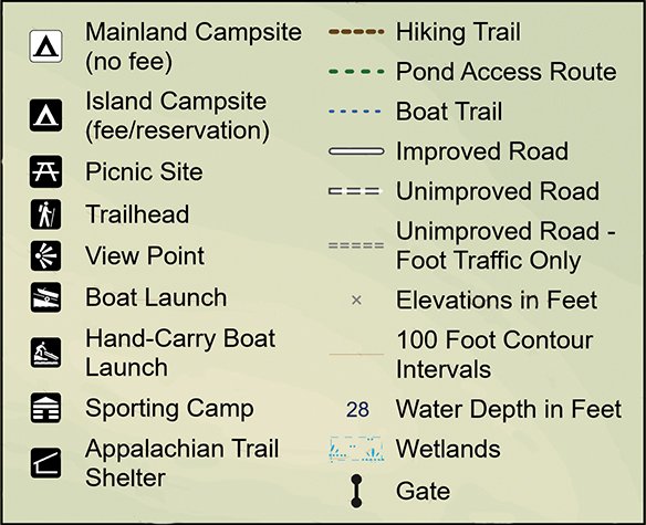
Map legend
BURNHAM TRAIL
Type of Trail: Out and back, with spur-trail option
Length: 2.1 miles to Landslide Overlook (4.2 miles roundtrip); 2.4 miles to High Pond (4.8 miles roundtrip); 2.7 miles to Helen Pond (5.4 miles roundtrip) and 3.3 miles to both Overlook and Helen Pond (6.6 miles roundtrip)
Elevation gain: Landslide Overlook = 1280'; High & Helen Ponds = 1520'; both destinations = 2020'
Difficulty: Moderately strenuous with an initial steep climb. Landslide Overlook spur is very steep.
Trailhead Location: Trailhead is at south end of Lindsay Cove parking lot. Can also be accessed directly from Cobbs Camps (add about 0.7 miles to above distances).
Description: Named after long-time Pierce-Ponder Charlie Burnham, this a long but rewarding hike to visit two beautiful remote ponds and/or a scenic lookout on the ridgeline of Pierce Pond Mountain. The Landslide Overlook spur trail is very steep and only for the sure-footed. There is a scenic lookout over Pierce Pond on the main trail just before the junction with the Landslide Overlook Trail. This trail crosses timber-company lands where harvesting has occurred in recent years.
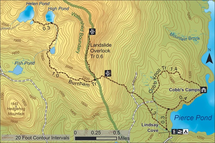
Burnham and Cobb knoll trails
COBB KNOLL TRAIL
Type of Trail: Loop trail
Length: 1.8 miles
Elevation gain: 320'
Difficulty: Moderate
Trailhead location: Trailhead is at Cobb’s Camps, though can be reached from Lindsay Cove parking lot (an additional 0.9 miles).
Description: A pleasant loop hike from Cobb’s Camps that provides a scenic lookout (from “the knoll”) looking east over Pierce Pond.
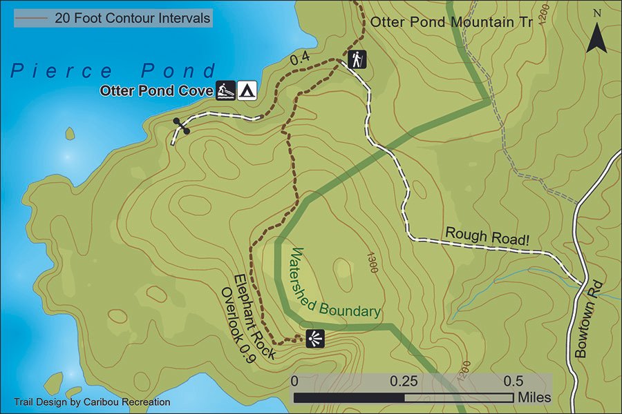
Elephant rock overlook trail
ELEPHANT ROCK OVERLOOK TRAIL
Type of Trail: Out and back
Length: 0.9 miles each way (1.8 miles round-trip)
Elevation gain: 180'
Difficulty: Moderate with some steep sections
Trailhead Location: Otter Pond Cove Road, about 0.4 miles from Otter Pond Cove boat launch. Small parking area on road. Across road from trailhead for Otter Pond Mountain Trail.
Description: Short, steeper at the start, with scenic lookout of Elephant Rock and the Basin at the end.
otter pond mountain trail
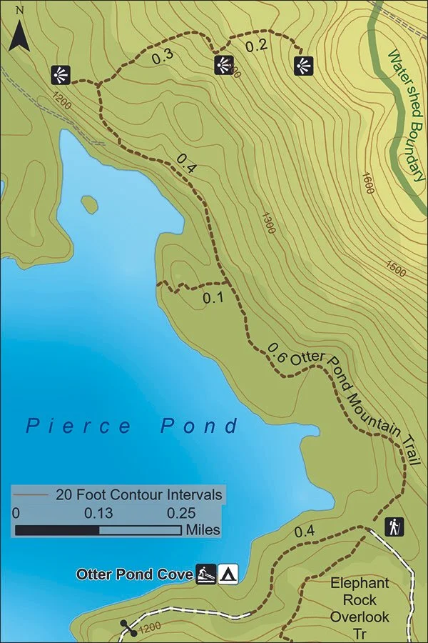
OTTER POND MOUNTAIN TRAIL
Type of Trail: Out and back
Length: 1.5 miles each way (3 miles round-trip)
Elevation gain: 360'
Difficulty: Moderate with some steep sections
Trailhead Location: Otter Pond Cove Road, about 0.4 miles from Otter Pond Cove boat launch. Small parking area on road. Across road from trailhead for Elephant Rock Overlook Trail.
Description: Yellow-blazed trail with numerous scenic viewpoints with views of Pierce Pond and the Bigelow Range. Some steep sections.
THREE-PONDS LOOP TRAIL AND GALE TRAIL
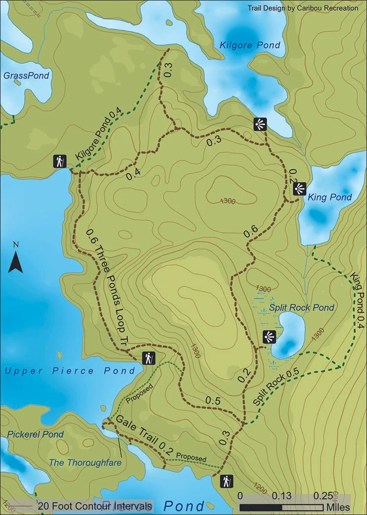
Three-Ponds Loop Trail
Type of Trail: Loop Trail
Length: 3.5 miles including side trails to the ponds
Elevation gain: 380'
Three-ponds loop trail and gale trail
Difficulty: Moderate with gentle terrain
Trailhead Location: There are three trailheads, all of which are accessed by water on Pierce Pond. One trailhead is on the north shore of Middle Pond in a cove about 400' east of the entrance to the Thoroughfare. There are two access points on the east shore of Upper Pond, the northernmost being at the trailhead to Kilgore Pond. All are marked with signs and yellow blazes.
Description: A longer hike, but along gentle terrain with limited elevation gain. There are side trails to overlooks on Split Rock, King, Kilgore, and Pierce Ponds, and beautiful sections of trail through mature forest. Please be aware that there are separate Pond-Access Trails (aka “Guides’ Trails”) to each of the smaller ponds for anglers to access boats.
Gale Trail and Thoroughfare Loop
Type of Trail: Out and back with optional loop
Length: Gale Trail = 0.2 miles; Thoroughfare Loop = approximately 1.2 miles (including Gale Trail)
Elevation gain: Gale Trail = none; Thoroughfare Loop = 140'
Difficulty: Easy
Trailhead Location: The Gale Trail trailhead is located just east of the Thoroughfare entrance on Middle Pond and ends up on the east side of the Thoroughfare on Upper Pond.
Description: The Gale Trail, named after long-time PPWT supporter Ben Gale, provides a short, easy way to walk from Middle to Upper Pierce Pond. It can be used in low water to allow boats to unload passengers, making for simpler passage through the Thoroughfare. The Thoroughfare Loop Trail (in planning stage at time of map printing) provides an easy, short loop hike by connecting into the Three-Ponds Loop Trail.
DOWNLOAD 8.5” x 11” PDFs:
Burnham & Cobb Knoll Trails
Elephant Rock Overlook Trail
Otter Pond Mountain Trail
Three-Ponds Loop & Gail Trails